Maritime traffic diverges sharply at Middle East chokepoints as Hormuz slows, Bab al-Mandab holds steady
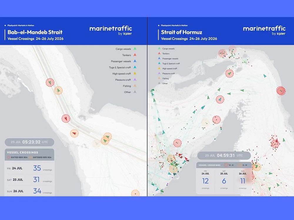
Ship-tracking data reveal contrasting patterns at two critical waterways: just 29 vessels crossed the Strait of Hormuz between July 24-26, while the Bab al-Mandab Strait recorded 100 transits during the same period.
Maritime traffic diverges sharply at Middle East chokepoints as Hormuz slows, Bab al-Mandab holds steady
Maritime traffic patterns have diverged dramatically across two of the world's most strategic shipping lanes in the Middle East, with the Strait of Hormuz experiencing a sharp slowdown while the Bab al-Mandab Strait maintained robust activity, according to ship-tracking data released this week.
Between July 24 and 26, only 29 verified vessel crossings were recorded through the Strait of Hormuz, the narrow waterway connecting the Arabian Gulf to the Gulf of Oman. Of those, 21 vessels exited the Middle East Gulf while eight entered. The strait, approximately 21 nautical miles wide at its narrowest point with shipping lanes just two miles wide in each direction, normally carries about 20 million barrels of oil per day under typical conditions, representing roughly one-fifth of global petroleum liquids consumption.
Routing through Hormuz was split among different navigation schemes, with 14 vessels using the Iranian unilateral system, 14 following undetermined routes, and one adhering to the Hormuz Traffic Separation Scheme, according to MarineTraffic, a leading global ship-tracking service.
Contrasting patterns at Bab al-Mandab
In stark contrast, the Bab al-Mandab Strait at the southern end of the Red Sea recorded 100 verified crossings during the same three-day period. Traffic was nearly balanced, with 51 vessels entering the Red Sea and 49 exiting. The waterway, approximately 18 miles wide at its narrowest point and divided by Perim Island into two channels, typically handles 10 to 12 percent of global seaborne trade.
The vast majority of Bab al-Mandab traffic—90 vessels—followed the established Traffic Separation Scheme, while 10 made what are known as dark transits with transponders switched off. Some vessels that had paused or reversed course ultimately proceeded through the strait, indicating that operators are continuously reassessing risks rather than abandoning the route entirely.
Strategic significance
The Strait of Hormuz serves as the primary export route for oil and liquefied natural gas from major producers including Saudi Arabia, Iraq, the United Arab Emirates, Kuwait and Iran. Saudi Arabia alone accounts for approximately 38 percent of crude oil flows through the strait at about 5.5 million barrels per day. Approximately 84 percent of crude oil and condensate shipped through Hormuz is destined for Asian markets, with China, India, Japan and South Korea as the top destinations.
The Bab al-Mandab functions as the gateway between the Indian Ocean and the Red Sea, leading to the Suez Canal and serving as a key route for Europe-bound cargo. Rerouting around Africa via the Cape of Good Hope adds approximately 3,000 to 3,500 nautical miles and 10 to 14 extra days to a typical Asia-to-Europe voyage.
Alternative routing options remain limited. Only Saudi Arabia and the United Arab Emirates operate crude oil pipelines that can bypass the Strait of Hormuz, with combined capacity of 3.5 to 5.5 million barrels per day—less than 35 percent of normal Hormuz throughput.
Regional tensions
The divergence comes amid heightened regional tensions, including confrontations between the United States and Iran, activities by Houthi forces linked to Yemen, and various attacks or threats affecting commercial shipping. Recent reports have noted reduced flows through Hormuz tied to security concerns, while Bab al-Mandab has seen fluctuating but sometimes resilient traffic as operators weigh alternatives.
MarineTraffic highlighted the contrasting patterns in a Monday post that included animated visualizations of vessel movements based on Automatic Identification System data and other intelligence sources.
The data underscore how geopolitical risks continue to influence commercial routing decisions, with potential ripple effects on global energy prices and supply chains. Shipping companies have previously diverted vessels, employed armed guards or turned off tracking systems in high-risk zones to mitigate threats.
Analysts monitor such chokepoints closely because sustained disruptions could exacerbate energy market volatility. The figures represent a snapshot of activity and can shift with new signals or changing conditions on the water.